Before a pipeline is installed, a port is expanded, or an offshore platform is positioned, project teams face a challenge that isn’t always visible.
What’s happening beneath the ground or seabed?
The answer can determine whether a project moves forward smoothly or encounters unexpected delays, redesigns, and additional costs.
Across Nigeria, developers, energy companies, engineering firms, and marine contractors increasingly rely on Geophysical Survey Nigeria services to reduce uncertainty before construction begins. The goal is straightforward: understand site conditions early enough to make informed decisions later.
At GEMS Nigeria, geophysical investigations support offshore, nearshore, and onshore developments by providing accurate subsurface information that engineers can use with confidence.
Why Early Site Investigation Matters
Many project risks remain hidden until excavation, drilling, dredging, or installation activities begin.
A route that appears suitable on a map may contain buried channels. A proposed offshore foundation location may sit above weak sediments. A pipeline corridor may cross areas affected by shallow gas accumulations or unstable seabed conditions.
These issues are rarely obvious during desktop studies.
That is why experienced project teams invest in site investigations before major engineering decisions are finalised.
Reliable survey data helps stakeholders:
- Identify geological hazards early
- Improve route and foundation selection
- Reduce construction uncertainty
- Support engineering design decisions
- Avoid costly modifications during execution
In practical terms, finding a problem during a survey is far less expensive than discovering it after construction equipment has already been mobilised.
The Growing Importance of Geophysical Exploration Nigeria
Over the past decade, project requirements across Nigeria have become more demanding.
Offshore developments are moving into deeper waters. Coastal infrastructure projects are expanding. Subsea cable installations continue to increase. At the same time, investors expect tighter schedules and greater cost control.
These factors have increased demand for professional Geophysical Exploration Nigeria services.
Unlike traditional intrusive investigations, geophysical exploration uses advanced instruments to collect information without extensive excavation or disturbance.
By measuring acoustic, seismic, magnetic, and bathymetric characteristics, survey teams can build a detailed picture of conditions beneath the surface.
Depending on project objectives, surveys may be used to:
- Assess offshore development locations
- Investigate pipeline and cable routes
- Identify geohazards
- Support oil and gas exploration activities
- Evaluate marine construction sites
- Assist coastal engineering projects
For many developments, this information becomes one of the earliest and most valuable inputs into the engineering process.
Technologies That Help Engineers See Beyond the Surface
Modern geophysical investigations combine multiple technologies to create a more complete understanding of subsurface conditions.
Multi-Beam Echo Sounders (MBES)
During offshore surveys, MBES systems are commonly used to generate detailed bathymetric maps of the seabed.
The resulting data reveals underwater terrain, slopes, depressions, and seabed features that may influence construction activities.
Side Scan Sonar (SSS)
Side scan sonar produces detailed acoustic imagery of the seafloor.
Survey teams use it to identify debris, wrecks, obstructions, exposed pipelines, and other features that could affect project execution.
Sub-Bottom Profilers (SBP)
Understanding what lies beneath the seabed surface is often just as important as mapping the surface itself.
Sub-bottom profilers help identify sediment layers, buried channels, shallow gas zones, and geological features that may influence foundation or pipeline design.
Seismic Reflection Surveys
For deeper investigations, seismic reflection methods provide valuable insight into geological structures below the seabed.
These surveys are frequently used as part of larger Geophysical Exploration Nigeria programs supporting energy and infrastructure developments.
Supporting Offshore Energy Projects
Nigeria remains one of Africa’s most significant offshore energy markets.
As exploration and development activities move into increasingly complex environments, the value of reliable survey data continues to grow.
A common misconception is that surveys simply produce maps.
In reality, survey findings often influence major project decisions.
For example, a proposed pipeline route may initially appear suitable. However, detailed geophysical data could reveal unstable sediments, steep seabed gradients, or shallow gas pockets along the corridor.
Identifying those conditions before installation allows engineers to adjust designs while changes are still relatively inexpensive.
Discovering the same issue during offshore construction can have a much larger impact on budgets and schedules.
This is one reason why geophysical surveys have become a standard part of offshore project planning.
Beyond Oil and Gas
Although offshore energy remains a major driver of demand, geophysical investigations support a much broader range of industries.
Port and Harbour Development
Bathymetric and sub-bottom data support dredging programs, berth construction, navigation planning, and port expansion projects.
Coastal Infrastructure
Survey information helps engineers design breakwaters, bridges, jetties, shoreline protection systems, and other marine structures.
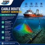
Subsea Cables
Telecommunications and power transmission projects rely on accurate route assessments to minimise long-term operational risks.
Environmental Studies
Survey data contributes to environmental baseline assessments and supports responsible marine development.
As Nigeria’s blue economy continues to expand, the need for dependable subsurface information is expected to grow alongside it.
Why Experience Matters as Much as Equipment
Technology plays an important role in modern surveys, but equipment alone does not guarantee reliable outcomes.
The true value of a survey comes from understanding what the data actually means.
Two teams may collect similar datasets and arrive at very different conclusions depending on their experience, interpretation methods, and familiarity with local conditions.
Nigeria’s offshore environment presents its own challenges, from soft deltaic sediments to rapidly changing seabed conditions in certain coastal regions.
At GEMS Nigeria, survey specialists combine advanced technology with regional project experience to transform raw survey results into practical engineering insight.
That combination helps clients move from data collection to confident decision-making.
Frequently Asked Questions
What is a Geophysical survey?
A geophysical survey uses specialised equipment to investigate subsurface or seabed conditions without extensive excavation. It helps identify geological features, hazards, and site conditions before development begins.
Why is Geophysical Survey Nigeria important for offshore projects?
It provides accurate information about seabed and subsurface conditions, helping engineers reduce risk, improve designs, and avoid costly surprises during construction.
What industries use Geophysical Exploration Nigeria services?
Oil and gas, marine infrastructure, coastal engineering, ports, telecommunications, environmental consulting, and renewable energy projects all rely on geophysical investigations.
How does geophysical exploration reduce project risk?
By identifying hazards and subsurface challenges early, project teams can make adjustments before major construction or installation activities begin.
Conclusion
By the time construction starts, many of the most important project decisions have already been made.
Those decisions depend on the quality of information available at the planning stage.
Whether supporting offshore energy developments, marine infrastructure projects, coastal engineering works, or subsea cable installations, Geophysical Survey Nigeria services provide the visibility needed to understand conditions before significant investments are committed.
Through advanced survey technologies, experienced personnel, and practical field knowledge, GEMS Nigeria helps clients replace uncertainty with clarity and build projects on a stronger foundation from day one.