The offshore energy landscape in Nigeria is entering its most technically demanding phase yet. As operators move from shallow-water shelf projects into the complex deep-water terrains of the Gulf of Guinea, the margin for error has effectively vanished. In this high-stakes environment, multi-million dollar infrastructure decisions can no longer be based on broad geological assumptions. They must be driven by high-fidelity, site-specific data.
At the forefront of this data revolution is GEMS (Geotechnical & Marine Services). With a deep-rooted track record across the West African continental margin, GEMS provides the best geotechnical services and comprehensive offshore oil and gas survey services designed to transform subsea uncertainty into actionable engineering intelligence.
Why Geotechnical Services are the Bedrock of Offshore Safety
Every offshore structure, whether a jack-up drilling unit, a sprawling subsea pipeline network, or a massive FPSO mooring system, is only as reliable as the seabed beneath it. However, the Nigerian maritime environment is far from uniform.
In the Niger Delta and surrounding basins, engineers face a “hidden” world of soft clays, rapidly accumulating sediments, and complex stratigraphy. These conditions introduce risks such as localised soil failure or excessive settlement that aren’t visible during surface inspections. GEMS delivers the best geotechnical services by deploying a “bottom-up” diagnostic approach:
- Advanced Soil Investigation: We utilise specialised drilling vessels capable of deep-water sampling to retrieve high-quality cores.
- In-Situ Testing (CPT & PCPT): Our Cone Penetration Testing (CPT) provides real-time data on soil resistance and pore pressure, which is vital for understanding how a foundation will behave under the immense weight of offshore steel.
- On-Site & Laboratory Analysis: By testing physical and mechanical properties such as shear strength, plasticity, and compressibility, we provide the exact parameters required for safe structural design.
By moving beyond “generalised” soil models, GEMS ensures that every foundation is optimised, strong enough to guarantee safety, but precise enough to avoid the massive costs of over-engineering.
Comprehensive Offshore Oil and Gas Survey Services
Understanding the seabed is a multi-layered challenge. You need to see the surface topography, but you also need to “look” beneath the mud line to identify hazards. GEMS provides offshore oil and gas survey services that integrate geophysical mapping with geotechnical ground-truthing to create a total site picture.
Geophysical Excellence and Hazard Identification
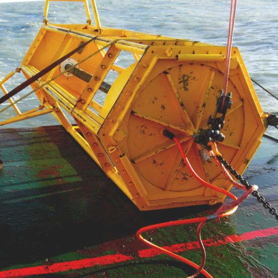
Before a drill bit touches the seabed or a pipe is laid, our survey teams deploy a suite of high-resolution sensors:
- Side Scan Sonar (SSS): To produce photo-like images of the seafloor, identifying everything from shipwrecks to existing debris.
- Multi-Beam Echo Sounders (MBES): To create 3D bathymetric maps that reveal the exact depth and “texture” of the terrain.
- Sub-Bottom Profilers (SBP): This is critical in Nigeria for identifying shallow gas pockets, one of the most dangerous hazards in offshore drilling that can lead to sudden rig instability.
Precision Route and Site Selection
The cost of re-routing a pipeline mid-project is staggering. Our offshore oil and gas survey services specialise in pre-lay route surveys that identify the path of least resistance. We look for stable gradients and avoid active fault lines or areas prone to submarine landslides, which are common on the steep continental slopes of the Gulf of Guinea.
The GEMS Advantage: Navigating the “Niger Delta Factor”
Offshore Nigeria is a unique beast. The high sedimentation rates from the Niger Delta river systems create under-consolidated soils that behave differently from those in the North Sea or the Gulf of Mexico.
What truly sets GEMS apart is our local operational intelligence. We don’t just bring equipment; we bring an understanding of regional seabed behaviour and the logistical realities of operating in West African waters.
- Regulatory Compliance: We work hand-in-hand with the standards set by the Nigerian Upstream Petroleum Regulatory Commission (NUPRC) and the NCDMB, ensuring that all data is compliant with official field development plans (FDPs).
- Risk Mitigation: Our data helps operators avoid “surprises” during the installation phase, which is where 70% of project cost overruns typically occur due to unforeseen ground conditions.
“In the offshore world, data is a commodity, but interpretation is a safeguard. GEMS bridges the gap between raw numbers and safe engineering.”
Subsea Asset Integrity and The Life of the Field
Our work doesn’t stop once the platform is installed. The dynamic nature of the ocean means the seabed is constantly changing. Scouring around pile legs or the shifting of sediments over pipelines can compromise a project years after completion.
GEMS offers long-term monitoring as part of our offshore oil and gas survey services. By performing periodic “integrity checks” using ROVs (Remotely Operated Vehicles) and high-resolution sonar, we help operators detect early signs of erosion or structural fatigue. This proactive approach extends the life of the asset and prevents catastrophic environmental incidents.
Pioneering the Future: Beyond Hydrocarbons
As the global energy mix shifts, the demand for high-tier geotechnical data is expanding. Nigeria’s “Blue Economy” is looking toward offshore wind potential, improved port infrastructure, and coastal protection projects.
The same rigours applied to oil and gas are required for these new frontiers. Whether it’s anchoring a wind turbine or dredging a new shipping channel, GEMS remains the partner of choice for providing the best geotechnical services that underpin Nigeria’s maritime future.
Final Thoughts: Data You Can Build On
In an industry where a single day of vessel downtime can cost hundreds of thousands of dollars, “guessing” is not an option. Success starts at the bottom, literally.
The combination of GEMS’ technical expertise in offshore oil and gas survey services and our precision-led best geotechnical services provides the “insurance policy” that every modern operator needs. We don’t just map the seafloor; we provide the confidence to build on it.
Empower your next project with precision. Explore our full range of marine and geotechnical capabilities at GEMS Nigeria.