If you speak to engineers working offshore in Nigeria, one thing comes up again and again: the seabed is never as simple as it looks on paper.
Over the years, oil and gas exploration has become far more advanced. But even with better seismic imaging and data tools, one reality hasn’t changed: if you don’t fully understand the ground you’re building on, problems show up later and usually at a high cost.
That’s exactly why modern oil and gas exploration techniques now go beyond just locating reserves. Today, a big part of the process is understanding how the seabed behaves before any structure touches it.
And this is where an offshore geotechnical survey in Nigeria starts to make a real difference.
The Evolution of Oil and Gas Exploration Techniques in the Niger Delta
Not too long ago, exploration in Nigeria relied heavily on seismic data and exploratory drilling. That approach worked well in simpler environments, but offshore conditions, especially in the Niger Delta, are far from simple.
In many areas, the seabed consists of soft clays, loose sediments, and layered deposits. These can behave unpredictably under pressure.
Today’s exploration approach reflects that reality. It usually combines:
• Seismic reflection surveys (2D, 3D, sometimes 4D)
• Borehole drilling and logging
• Geophysical mapping
• Detailed geotechnical investigations
The shift is quite practical. Instead of just asking “Is there oil here?”, teams are now asking:
“Can we safely build and operate here for the next 20–30 years?”
That’s a completely different level of planning.
Key Components of an Offshore Geotechnical Survey in Nigeria
A proper offshore geotechnical survey in Nigeria isn’t a single activity. It’s a combination of fieldwork and analysis that helps engineers understand how the seabed will respond during installation and long-term operations.
Soil Sampling and In-situ Testing: Ensuring Foundation Integrity
This is usually where things get hands-on.
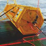
Survey teams collect seabed samples using tools like gravity corers or vibrocorers. These samples are then tested to understand:
• Soil strength
• Density and composition
• Consolidation behavior
• Load-bearing capacity
But sampling alone isn’t enough. That’s why in-situ testing methods such as Cone Penetration Testing (CPT) and Piezocone Penetrometer Testing (PCPT) are widely used offshore.
These tools give real-time data as they penetrate the seabed, helping engineers see how soil conditions change with depth.
From experience, this is often where surprises show up, layers that look stable in theory but behave differently under pressure.
Why This Data Actually Matters Offshore
It’s easy to say surveys “improve safety,” but offshore, the impact is much more specific.
For example:
Jack-up rig punch-through: This happens when one leg of the rig suddenly sinks into weak soil
Pipeline instability: pipelines can shift or sag if the seabed isn’t properly understood. Mudslides on slopes: especially in deeper offshore zones
In parts of Nigeria’s offshore region, particularly along the continental slope, these risks are not uncommon.
A well-executed offshore geotechnical survey in Nigeria helps teams spot these issues early before installation begins.
And in real terms, that can mean the difference between a smooth project and months of rework.
A Practical Scenario (Where Surveys Save Money)
Let’s take a simple example.
Imagine a pipeline project offshore Lagos. The route looks fine based on geophysical data. Everything checks out on the surface.
But once geotechnical testing is done, it reveals a layer of weak, potentially liquefiable soil.
If that detail is missed, the pipeline could shift over time, especially under pressure or during strong currents.
Fixing that later? Extremely expensive.
Catching it early? You adjust the design, maybe reinforce the route problem solved before it begins.
This is exactly why geotechnical surveys are treated as a critical step, not just a formality.
Regulatory Compliance in Nigeria’s Offshore Projects
There’s also the regulatory side to consider.
Offshore operations in Nigeria are expected to meet strict guidelines, especially when it comes to safety and environmental impact.
Geotechnical data is often required to:
• Support environmental assessments
• Validate structural designs
Secure project approvals
Without proper survey documentation, projects can face delays or worse, fail to meet compliance standards altogether.
So, beyond engineering, surveys also help keep projects aligned with industry expectations.
Supporting Smarter and More Sustainable Development
Another thing that’s becoming more important is sustainability.
Offshore projects are now expected to minimise environmental disruption, especially in sensitive marine areas.
Geotechnical insights help here, too. By understanding sediment movement and seabed conditions, teams can avoid unstable zones or areas that could cause long-term environmental issues.
It’s not just about building, it’s about building responsibly.
Final Thoughts
If there’s one thing offshore teams have learned over time, it’s this:
What you don’t know about the seabed can cost you later.
Modern oil and gas exploration techniques are no longer just about discovery. They’re about reducing uncertainty as much as possible before operations begin.
In Nigeria, where offshore conditions can vary significantly, a detailed offshore geotechnical survey in Nigeria gives project teams the clarity they need to move forward with confidence.
It’s not the most visible part of a project, but it’s often one of the most important.